

How to get from Ottumwa (Iowa) to Fort Dodge (Iowa)
Calculate route from Ottumwa (Iowa, United States) to Fort Dodge (Iowa, United States).
The flight distance (as the crow flies) between Ottumwa and Fort Dodge is 219.4 km.
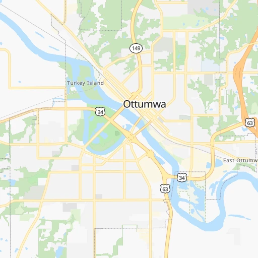
Roadmap (route) to go from Ottumwa to Fort Dodge detailed above, you can also see the course layout on the map.
While doing trip Ottumwa - Fort Dodge by car, the calculated route ends at a distance , or more straight.
Distance and duration of the route between Ottumwa and Fort Dodge
Calculation of distance and route from Fort Dodge to Ottumwa :
219.4279.9 km3h9mn
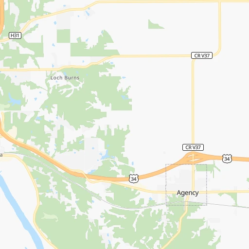
Continue onto West Fourth Street 0h0mn 354 mTurn left onto South Wapello Street 0h0mn 3 mKeep right 0h0mn 169 mTurn right onto West Second Street 0h14mn 11.8 kmTurn left onto US 63, IA 163 1h47mn 74.2 kmKeep right and take IA 14 toward Monroe, Newton 0h1mn 620 mTurn right onto State Highway 14 0h0mn 527 mTurn left onto Sherman Street 0h4mn 4.0 kmTurn right 0h24mn 32.8 kmTurn right 0h4mn 6.8 kmKeep left and take I 80 West toward Council Bluffs 0h3mn 4.6 kmKeep right and take I 35 North toward Minneapolis 1h54mn 89.7 kmKeep right and take US 20 West toward Fort Dodge 0h29mn 45.6 kmKeep right onto US 20 Business 0h0mn 525 mTurn right onto Nelson Avenue 0h2mn 2.4 kmTurn left onto 220th Street 0h4mn 4.4 kmTurn left onto 8th Avenue South 0h2mn 1.6 kmArrive at destination 0h0mn 0 m
Travel from Ottumwa (Iowa) to a selection of major cities.
Distances from Ottumwa to biggest cities in Iowa
- Muscatine,23,968 inhabitants.123 km
- Johnston,20,871 inhabitants.130 km
- Coralville,20,608 inhabitants.101 km
Other major cities in country :
- Charlotte [NC], 827,097 inhabitants. 1,199 km
- Seattle [WA], 684,451 inhabitants. 2,476 km
- Denver [CO], 682,545 inhabitants. 1,075 km
- El Paso [TX], 681,124 inhabitants. 1,625 km
- Detroit [MI], 677,116 inhabitants. 792 km
- Boston [MA], 667,137 inhabitants. 1,776 km
- Memphis [TN], 655,770 inhabitants. 685 km
- New South Memphis [TN], 641,608 inhabitants. 692 km
- Portland [OR], 632,309 inhabitants. 2,488 km
- Oklahoma City [OK], 631,346 inhabitants. 762 km
- Las Vegas [NV], 623,747 inhabitants. 2,043 km
- Baltimore [MD], 621,849 inhabitants. 1,356 km
- Washington, D.C. [DC], 601,723 inhabitants. 1,331 km
- Milwaukee [WI], 600,155 inhabitants. 435 km
- South Boston [MA], 571,281 inhabitants. 1,777 km
- Albuquerque [NM], 559,121 inhabitants. 1,410 km
- Tucson [AZ], 531,641 inhabitants. 1,916 km
- Nashville [TN], 530,852 inhabitants. 729 km
- Fresno [CA], 520,052 inhabitants. 2,408 km
- Sacramento [CA], 490,712 inhabitants. 2,490 km
Route from Fort Dodge to major cities (United States).
- Distance Fort Dodge New York City1,686 km
- Distance Fort Dodge Los Angeles2,294 km
- Distance Fort Dodge Chicago542 km
- Distance Fort Dodge Brooklyn1,692 km
- Distance Fort Dodge Houston1,422 km
- Distance Fort Dodge Queens1,701 km
- Distance Fort Dodge Philadelphia1,613 km
- Distance Fort Dodge Phoenix1,861 km
- Distance Fort Dodge Manhattan1,687 km
- Distance Fort Dodge San Antonio1,506 km
- Distance Fort Dodge San Diego2,291 km
- Distance Fort Dodge The Bronx1,694 km
- Distance Fort Dodge Dallas1,106 km
- Distance Fort Dodge San Jose2,424 km
- Distance Fort Dodge Austin1,398 km
- Distance Fort Dodge Jacksonville1,754 km
- Distance Fort Dodge San Francisco2,449 km
- Distance Fort Dodge Columbus976 km
- Distance Fort Dodge Fort Worth1,123 km
- Distance Fort Dodge Indianapolis737 km
Nearest cities to Ottumwa :
- Kansas City, 475,378 inhabitants. 282 km
- St. Louis, 315,685 inhabitants. 327 km
- Des Moines, 210,330 inhabitants. 119 km
- Overland Park, 186,515 inhabitants. 298 km
- Kansas City, 151,306 inhabitants. 284 km
- Olathe, 134,305 inhabitants. 314 km
- Cedar Rapids, 130,405 inhabitants. 127 km
- Columbia, 119,108 inhabitants. 230 km
- Independence, 117,255 inhabitants. 274 km
- Springfield, 116,565 inhabitants. 271 km
- Peoria, 115,070 inhabitants. 240 km
- North Peoria, 113,004 inhabitants. 240 km
- East Independence, 110,675 inhabitants. 271 km
- Davenport, 102,582 inhabitants. 163 km
- Lee's Summit, 95,094 inhabitants. 289 km
- Lawrence, 93,917 inhabitants. 332 km
- O'Fallon, 85,040 inhabitants. 286 km
- Saint Joseph, 76,780 inhabitants. 249 km
- Iowa City, 74,220 inhabitants. 103 km
- Waterloo, 68,460 inhabitants. 164 km
- Saint Charles, 65,794 inhabitants. 299 km
- Ames, 65,060 inhabitants. 151 km
- Shawnee, 65,046 inhabitants. 295 km
- West Des Moines, 64,113 inhabitants. 125 km
- Dubuque, 58,799 inhabitants. 220 km
- Ankeny, 56,764 inhabitants. 127 km
- Blue Springs, 54,148 inhabitants. 274 km
- Saint Peters, 52,575 inhabitants. 290 km
- Lenexa, 52,490 inhabitants. 304 km
- La Crosse, 52,306 inhabitants. 324 km
- Florissant, 52,268 inhabitants. 306 km
- North La Crosse, 50,470 inhabitants. 329 km
- Chesterfield, 47,864 inhabitants. 306 km
- Urbandale, 44,062 inhabitants. 128 km
- Jefferson City, 43,169 inhabitants. 273 km
- Moline, 42,681 inhabitants. 168 km
- Belleville, 42,034 inhabitants. 347 km
- Cedar Falls, 41,255 inhabitants. 168 km
- Quincy, 40,780 inhabitants. 148 km
- Rock Island, 38,620 inhabitants. 163 km
- Marion, 37,330 inhabitants. 132 km
- Oakville, 36,143 inhabitants. 336 km
- Leavenworth, 35,980 inhabitants. 286 km
- Wildwood, 35,899 inhabitants. 310 km
- Wentzville, 35,603 inhabitants. 280 km
- Bettendorf, 35,505 inhabitants. 168 km
- University City, 35,058 inhabitants. 319 km
- Leawood, 34,579 inhabitants. 296 km
- Pekin, 33,223 inhabitants. 239 km
- Galesburg, 31,273 inhabitants. 172 km
Location Ottumwa (Iowa) :
| Country flag |  |
| Location | Ottumwa |
| State | Iowa |
| County | Wapello County |
| Country | United States |
| Country code / ISO 2 | US |
| Latitude | 41.0200100 |
| Longitude | -92.4113000 |
| Altitude | 205 meters |
| Time zone | America/Chicago |
Location Fort Dodge (Iowa) :
| Country flag | |
| Location | Fort Dodge |
| State | Iowa |
| County | Webster County |
| Country | United States |
| Country code / ISO 2 | US |
| Latitude | 42.4974700 |
| Longitude | -94.1680200 |
| Altitude | 340 meters |
| Time zone | America/Chicago |


