
How to get from Tepalcatepec (Michoacán) to Nueva Italia de Ruiz (Michoacán)
Calculate route from Tepalcatepec (Michoacán, Mexico) to Nueva Italia de Ruiz (Michoacán, Mexico).
The flight distance (as the crow flies) between Tepalcatepec and Nueva Italia de Ruiz is 81.4 km.
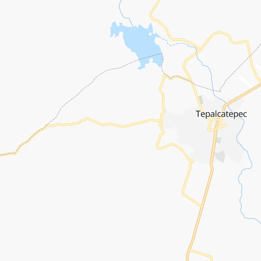
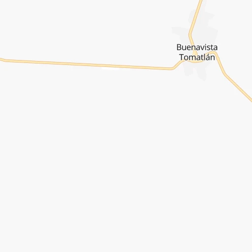
Roadmap (route) to go from Tepalcatepec to Nueva Italia de Ruiz detailed above, you can also see the course layout on the map.
While doing trip Tepalcatepec - Nueva Italia de Ruiz by car, the calculated route ends at a distance , or more straight.
Distance and duration of the route between Tepalcatepec and Nueva Italia de Ruiz
Calculation of distance and route from Nueva Italia de Ruiz to Tepalcatepec :
81.4102.0 km2h31mn
Continue onto Avenida Las Américas 0h0mn 214 mAt roundabout, take exit 3 onto Calle Belisario Domínguez 0h1mn 603 mTurn right onto Avenida Miguel Hidalgo 0h0mn 112 mTurn left onto Quiroga - Tepalcatepec 1h59mn 65.5 kmAt roundabout, take exit 3 onto Quiroga - Tepalcatepec 0h1mn 1.5 kmAt roundabout, take exit 2 onto Quiroga - Tepalcatepec 0h26mn 29.9 kmAt roundabout, take exit 3 onto Calle Lázaro Cárdenas Sur 0h4mn 4.0 kmMake a U-turn onto Avenida Lázaro Cárdenas Norte 0h0mn 57 mArrive at destination 0h0mn 0 m
Travel from Tepalcatepec (Michoacán) to a selection of major cities.
Distances from Tepalcatepec to biggest cities in Michoacán
Other major cities in country :
- Aguascalientes [01], 658,179 inhabitants. 306 km
- Acapulco de Juarez [12], 652,136 inhabitants. 406 km
- Coyoacan [09], 628,063 inhabitants. 388 km
- Santiago de Queretaro [22], 626,495 inhabitants. 301 km
- Saltillo [07], 621,250 inhabitants. 720 km
- Tlalpan [09], 607,545 inhabitants. 388 km
- Mexicali [02], 597,099 inhabitants. 1,954 km
- Hermosillo [26], 595,811 inhabitants. 1,377 km
- Veracruz [30], 568,313 inhabitants. 705 km
- Cancun [23], 542,043 inhabitants. 1,686 km
- Santa Maria Chimalhuacan [15], 525,389 inhabitants. 410 km
- Torreon [07], 524,066 inhabitants. 710 km
- Cuauhtemoc [09], 521,348 inhabitants. 390 km
- Ciudad Lopez Mateos [15], 521,034 inhabitants. 380 km
- Toluca [15], 505,881 inhabitants. 336 km
- Reynosa [28], 498,654 inhabitants. 899 km
- Tlaquepaque [14], 493,646 inhabitants. 168 km
- Tuxtla [05], 481,128 inhabitants. 1,066 km
- Cuautitlan Izcalli [15], 475,179 inhabitants. 385 km
- Victoria de Durango [10], 457,140 inhabitants. 570 km
Route from Nueva Italia de Ruiz to major cities (Mexico).
- Distance Nueva Italia de Ruiz Mexico City315 km
- Distance Nueva Italia de Ruiz Iztapalapa321 km
- Distance Nueva Italia de Ruiz Ecatepec de Morelos325 km
- Distance Nueva Italia de Ruiz Guadalajara228 km
- Distance Nueva Italia de Ruiz Puebla409 km
- Distance Nueva Italia de Ruiz Juarez1,479 km
- Distance Nueva Italia de Ruiz Tijuana2,113 km
- Distance Nueva Italia de Ruiz Ciudad Nezahualcoyotl326 km
- Distance Nueva Italia de Ruiz Gustavo Adolfo Madero318 km
- Distance Nueva Italia de Ruiz Monterrey762 km
- Distance Nueva Italia de Ruiz Leon de los Aldama238 km
- Distance Nueva Italia de Ruiz Zapopan232 km
- Distance Nueva Italia de Ruiz Naucalpan de Juarez304 km
- Distance Nueva Italia de Ruiz Chihuahua1,144 km
- Distance Nueva Italia de Ruiz Alvaro Obregon306 km
- Distance Nueva Italia de Ruiz Guadalupe764 km
- Distance Nueva Italia de Ruiz Merida1,323 km
- Distance Nueva Italia de Ruiz Tlalnepantla310 km
- Distance Nueva Italia de Ruiz San Luis Potosi367 km
- Distance Nueva Italia de Ruiz Culiacan843 km
Nearest cities to Tepalcatepec :
- Guadalajara, 1,640,589 inhabitants. 174 km
- Leon de los Aldama, 1,114,626 inhabitants. 249 km
- Zapopan, 987,516 inhabitants. 180 km
- San Luis Potosi, 677,704 inhabitants. 383 km
- Aguascalientes, 658,179 inhabitants. 306 km
- Acapulco de Juarez, 652,136 inhabitants. 406 km
- Santiago de Queretaro, 626,495 inhabitants. 301 km
- Morelia, 592,797 inhabitants. 184 km
- Tlaquepaque, 493,646 inhabitants. 168 km
- Tonala, 401,509 inhabitants. 165 km
- Irapuato, 339,554 inhabitants. 228 km
- Celaya, 305,901 inhabitants. 260 km
- Tepic, 280,592 inhabitants. 335 km
- Uruapan, 237,308 inhabitants. 87 km
- Puerto Vallarta, 187,134 inhabitants. 296 km
- Salamanca, 138,614 inhabitants. 232 km
- Colima, 127,235 inhabitants. 93 km
- Zamora, 124,916 inhabitants. 107 km
- San Juan del Rio, 118,173 inhabitants. 327 km
- Ciudad de Villa de Alvarez, 117,600 inhabitants. 94 km
- El Salto, 111,436 inhabitants. 152 km
- Manzanillo, 110,735 inhabitants. 157 km
- Ciudad Guzman, 101,010 inhabitants. 86 km
- Apatzingan, 98,422 inhabitants. 53 km
- Hacienda Santa Fe, 86,935 inhabitants. 158 km
- Lagos de Moreno, 84,677 inhabitants. 260 km
- Ciudad Lazaro Cardenas, 84,001 inhabitants. 151 km
- Tepatitlan de Morelos, 83,694 inhabitants. 182 km
- Ocotlan, 81,527 inhabitants. 130 km
- Tecoman, 79,579 inhabitants. 112 km
- Heroica Zitacuaro, 78,950 inhabitants. 263 km
- Guanajuato, 78,364 inhabitants. 263 km
- La Piedad, 70,238 inhabitants. 155 km
- San Miguel de Allende, 69,811 inhabitants. 292 km
- San Francisco del Rincon, 66,949 inhabitants. 229 km
- Silao, 65,195 inhabitants. 246 km
- Ixtapa-Zihuatanejo, 61,308 inhabitants. 220 km
- Valle de Santiago, 60,528 inhabitants. 219 km
- Dolores Hidalgo Cuna de la Independencia Nacional, 59,240 inhabitants. 297 km
- Sahuayo de Morelos, 58,513 inhabitants. 98 km
- Cortazar, 56,360 inhabitants. 245 km
- Acambaro, 56,263 inhabitants. 242 km
- Ciudad Hidalgo, 54,993 inhabitants. 247 km
- Zacapu, 50,112 inhabitants. 131 km
- Uriangato, 49,745 inhabitants. 204 km
- Patzcuaro, 49,016 inhabitants. 135 km
- Rioverde, 48,854 inhabitants. 426 km
- San Luis de la Paz, 47,321 inhabitants. 338 km
- San Juan de los Lagos, 45,671 inhabitants. 236 km
- Arandas, 43,342 inhabitants. 177 km
Location Tepalcatepec (Michoacán) :
| Country flag |  |
| Location | Tepalcatepec |
| State | Michoacán |
| County | Tepalcatepec |
| Country | Mexico |
| Country code / ISO 2 | MX |
| Latitude | 19.1866600 |
| Longitude | -102.8493000 |
| Altitude | 0 meters |
| Time zone | America/Mexico_City |
Location Nueva Italia de Ruiz (Michoacán) :
| Country flag | |
| Location | Nueva Italia de Ruiz |
| State | Michoacán |
| County | Múgica |
| Country | Mexico |
| Country code / ISO 2 | MX |
| Latitude | 19.0249200 |
| Longitude | -102.0931800 |
| Altitude | 0 meters |
| Time zone | America/Mexico_City |
