
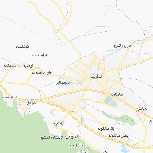


How to get from Langarūd (Gīlān) to Āstāneh-ye Ashrafīyeh (Gīlān)
Calculate route from Langarūd (Gīlān, Iran) to Āstāneh-ye Ashrafīyeh (Gīlān, Iran).
The flight distance (as the crow flies) between Langarūd and Āstāneh-ye Ashrafīyeh is 20.0 km.
Roadmap (route) to go from Langarūd to Āstāneh-ye Ashrafīyeh detailed above, you can also see the course layout on the map.
While doing trip Langarūd - Āstāneh-ye Ashrafīyeh by car, the calculated route ends at a distance , or more straight.
Distance and duration of the route between Langarūd and Āstāneh-ye Ashrafīyeh
Calculation of distance and route from Āstāneh-ye Ashrafīyeh to Langarūd :
20.024.9 km0h26mn
Continue onto کوچه فرید 0h0mn 109 mTurn right onto رسالت 0h0mn 76 mTurn right onto مدرس 0h0mn 184 mTurn sharp right onto بلوار امام خمینی 0h0mn 230 mAt roundabout, take exit 1 onto بلوار شهید بهشتی 0h2mn 834 mAt roundabout, take exit 1 onto بلوار حافظ 0h1mn 695 mAt roundabout, take exit 2 onto بلوار حافظ 0h2mn 1.4 kmAt roundabout, take exit 2 onto لنگرود - لاهیجان 0h6mn 8.0 kmAt roundabout, take exit 2 onto بلوار امام رضا 0h2mn 1.8 kmAt roundabout, take exit 1 onto بلوار امام رضا 0h1mn 617 mAt roundabout, take exit 2 onto بلوار امام رضا 0h0mn 337 mAt roundabout, take exit 3 onto امام خمینی 0h0mn 164 mKeep right onto امام خمینی شرقی 0h1mn 490 mAt roundabout, take exit 3 onto خیابان امام خمینی شرقی 0h0mn 248 mAt roundabout, take exit 2 onto خیابان امام خمینی غربی 0h1mn 667 mAt roundabout, take exit 2 onto بلوار شهید چایی پز 0h0mn 412 mAt roundabout, take exit 2 onto بلوار عدالت 0h2mn 1.7 kmAt roundabout, take exit 3 onto لاهیجان - آستانه 0h4mn 4.8 kmAt roundabout, take exit 2 onto بلوار آزادی 0h1mn 603 mAt roundabout, take exit 2 onto فردوسی 0h0mn 185 mTurn sharp right 0h0mn 66 mTurn left onto صفری 0h0mn 68 mKeep left onto صفری 0h1mn 293 mTurn left onto شهید جعفرپور 0h0mn 56 mTurn right onto شهید نوری دژبرد 0h0mn 42 mTurn sharp left onto حافظ 0h0mn 31 mKeep right onto حافظ 0h0mn 32 mKeep right onto شهید جعفرپور 0h0mn 75 mTurn right onto استقلال 0h0mn 8 mTurn left onto میربلوک 0h0mn 218 mTurn right 0h0mn 53 mTurn sharp left onto نواب صفوی 0h0mn 102 mTurn right onto زهرا علیدوست 0h0mn 78 mTurn right onto نظری 0h0mn 18 mTurn left onto تقوی 0h0mn 189 mTurn right onto خیابان شریعتی 0h0mn 63 mTurn right 0h0mn 50 mArrive at destination 0h0mn 0 m
Travel from Langarūd (Gīlān) to a selection of major cities.
Distances from Langarūd to biggest cities in Gīlān
Other major cities in country :
- Zanjan [36], 357,471 inhabitants. 158 km
- Bandar Abbas [11], 352,173 inhabitants. 1,254 km
- Sanandaj [16], 349,176 inhabitants. 352 km
- Qazvin [38], 333,635 inhabitants. 104 km
- Khorramshahr [15], 330,606 inhabitants. 774 km
- Khorramabad [23], 329,825 inhabitants. 444 km
- Khomeyni Shahr [28], 277,334 inhabitants. 518 km
- Sari [35], 255,396 inhabitants. 268 km
- Borujerd [23], 251,958 inhabitants. 388 km
- Qarchak [26], 251,834 inhabitants. 234 km
- Gorgan [37], 244,937 inhabitants. 383 km
- Sabzevar [42], 226,183 inhabitants. 681 km
- Najafabad [28], 223,450 inhabitants. 520 km
- Neyshabur [42], 220,929 inhabitants. 779 km
- Nazarabad [44], 213,388 inhabitants. 144 km
- Bukan [01], 213,331 inhabitants. 359 km
- Sirjan [29], 207,645 inhabitants. 1,003 km
- Babol [35], 202,796 inhabitants. 236 km
- Amol [35], 199,382 inhabitants. 212 km
- Birjand [41], 196,982 inhabitants. 956 km
Route from Āstāneh-ye Ashrafīyeh to major cities (Iran).
- Distance Āstāneh-ye Ashrafīyeh Tehran219 km
- Distance Āstāneh-ye Ashrafīyeh Mashhad864 km
- Distance Āstāneh-ye Ashrafīyeh Isfahan537 km
- Distance Āstāneh-ye Ashrafīyeh Karaj185 km
- Distance Āstāneh-ye Ashrafīyeh Tabriz334 km
- Distance Āstāneh-ye Ashrafīyeh Shiraz885 km
- Distance Āstāneh-ye Ashrafīyeh Qom304 km
- Distance Āstāneh-ye Ashrafīyeh Ahvaz672 km
- Distance Āstāneh-ye Ashrafīyeh Pasragad Branch307 km
- Distance Āstāneh-ye Ashrafīyeh Kahriz413 km
- Distance Āstāneh-ye Ashrafīyeh Kermanshah419 km
- Distance Āstāneh-ye Ashrafīyeh Kerman1,019 km
- Distance Āstāneh-ye Ashrafīyeh Orumiyeh432 km
- Distance Āstāneh-ye Ashrafīyeh Zahedan1,332 km
- Distance Āstāneh-ye Ashrafīyeh Hamadan303 km
- Distance Āstāneh-ye Ashrafīyeh Azadshahr302 km
- Distance Āstāneh-ye Ashrafīyeh Arak353 km
- Distance Āstāneh-ye Ashrafīyeh Yazd722 km
- Distance Āstāneh-ye Ashrafīyeh Ardabil182 km
- Distance Āstāneh-ye Ashrafīyeh Abadan786 km
Nearest cities to Langarūd :
- Tehran, 7,153,309 inhabitants. 202 km
- Karaj, 1,448,075 inhabitants. 169 km
- Qom, 900,000 inhabitants. 292 km
- Pasragad Branch, 787,878 inhabitants. 309 km
- Rasht, 594,590 inhabitants. 51 km
- Hamadan, 528,256 inhabitants. 305 km
- Azadshahr, 514,102 inhabitants. 303 km
- Ardabil, 410,753 inhabitants. 201 km
- Zanjan, 357,471 inhabitants. 158 km
- Qazvin, 333,635 inhabitants. 104 km
- Sari, 255,396 inhabitants. 268 km
- Qarchak, 251,834 inhabitants. 234 km
- Nazarabad, 213,388 inhabitants. 144 km
- Babol, 202,796 inhabitants. 236 km
- Amol, 199,382 inhabitants. 212 km
- Varamin, 179,603 inhabitants. 248 km
- Malayer, 176,573 inhabitants. 344 km
- Saveh, 175,533 inhabitants. 243 km
- Bandar-e Anzali, 110,826 inhabitants. 69 km
- Parsabad, 101,661 inhabitants. 335 km
- Qorveh, 87,953 inhabitants. 309 km
- Shahre Jadide Andisheh, 80,000 inhabitants. 186 km
- Alvand, 74,889 inhabitants. 131 km
- Takestan, 71,499 inhabitants. 132 km
- Abhar, 69,889 inhabitants. 143 km
- Chalus, 69,638 inhabitants. 128 km
- Langarud, 68,148 inhabitants. 0 km
- Robat Karim, 62,753 inhabitants. 208 km
- Asadabad, 59,617 inhabitants. 325 km
- Shahriar, 58,849 inhabitants. 189 km
- Harsin, 57,647 inhabitants. 400 km
- Malard, 56,745 inhabitants. 186 km
- Abyek, 55,128 inhabitants. 131 km
- Bijar, 53,871 inhabitants. 272 km
- Pishva, 53,856 inhabitants. 253 km
- Kangavar, 53,414 inhabitants. 359 km
- Khalkhal, 51,024 inhabitants. 151 km
- Khorramdarreh, 50,528 inhabitants. 139 km
- Istgah-e Rah Ahan-e Garmsar, 49,491 inhabitants. 292 km
- Babolsar, 48,051 inhabitants. 229 km
- Rudsar, 47,502 inhabitants. 14 km
- Hashtpar, 45,305 inhabitants. 129 km
- Sonqor, 43,174 inhabitants. 354 km
- Astaneh-ye Ashrafiyeh, 42,784 inhabitants. 20 km
- Nowshahr, 40,000 inhabitants. 134 km
- Astara, 39,065 inhabitants. 178 km
- Tonekabon, 37,501 inhabitants. 77 km
- Eqbaliyeh, 36,709 inhabitants. 245 km
- Fereydunkenar, 34,097 inhabitants. 218 km
- Damavand, 29,144 inhabitants. 238 km
Location Langarūd (Gīlān) :
| Country flag |  |
| Location | Langarūd |
| State | Gīlān |
| County | |
| Country | Iran |
| Country code / ISO 2 | IR |
| Latitude | 37.1954800 |
| Longitude | 50.1526300 |
| Altitude | 0 meters |
| Time zone | Asia/Tehran |
Location Āstāneh-ye Ashrafīyeh (Gīlān) :
| Country flag | |
| Location | Āstāneh-ye Ashrafīyeh |
| State | Gīlān |
| County | |
| Country | Iran |
| Country code / ISO 2 | IR |
| Latitude | 37.2631800 |
| Longitude | 49.9432500 |
| Altitude | 0 meters |
| Time zone | Asia/Tehran |